The Middle Tellico Whitewater River provides a special kind of exhilaration that begins long before my paddle touches water.
For kayakers, the Tellico River is “in play” when rains in the Blue Ridge Mountains, and specifically the Unicoi Mountain Range, bring a flow of water into the gorges that are folded into the landscape. The Tellico River carves through the bones of these ancient mountains.
Waterflow means everything. Sudden rainfall in the mountains can turn an otherwise lackadaisical stream into a raging current ideal for whitewater shenanigans.
Text messages on my phone begin days in advance:
“Storm’s a brewin’. Where we paddling this weekend?”
We watch our weather apps like a hawk. If a storm drops water on the other side of the ridgeline, our favorite rivers won’t be in play. However, if the jet-stream shifts slightly, raindrops will fill the valleys nearer our homes.
Websites like www.AmericanWhiteWater.org and the USGS Streamflow table help us make the decision.
Anticipation mounts as the local news station’s weather radar shows intensifying cloud cover. When the rain starts falling, our phones blow up with text messages.
“The gauge is reading 1.4 and rising. Tellico’s gonna go tomorrow!!!”
The USGS operates a network of stream gauges that reports streamflows in many rivers. Gauge readings are useful for interpreting the expected levels of the river. Too low of a flow means our boats will scrape and grind across the rocks. Too high of a flow means the holes and eddies will be too difficult for our skill level.
As the rains fall on a weekday in mid-June, the gauge peaks overnight before it begins falling, indicating an expected level of 1.9’ the next day…ideal for my crew’s skillset.
“Meet at 11:00AM. Oosterneck!!!”
The stage is set and the plan is in place. I will meet my friends at the Oosterneck Pull-Off. There, we will set shuttle, combine all our boats and gear into one vehicle, then drive to the put-in.
“GAME’S ON!!!!”
On this day, we decide not to run the Ledges section of the Tellico which includes Baby Falls, Diaper Wiper, and the Class IV Jarod’s Knee set of rapids. Instead, we will put in at the traditional start of the middle section.
This run down the Middle Tellico River offers the familiar rush of adrenaline that all kayakers chase, not only from the river’s rapids but also from the camaraderie of friends.
A Grand Opening: Bald River Falls & the New Pedestrian Bridge
The video begins with one of East Tennessee’s most iconic views of Bald River Falls. Towering over the Bald River just before it meets the Tellico, the falls roar with a power that demands reverence. On this trip, I take a moment to appreciate the newly built pedestrian bridge and observation platform. This new bridge is two years in the making.
During this two-year downtime, the river has been inaccessible to kayakers.
Although not being able to get on the Tellico for two years has been disheartening, the new bridge is a welcome improvement for visitors, providing safe and sweeping views of the cascade while preserving the fragile terrain beneath.
The Tellico’s Geologic Puzzle
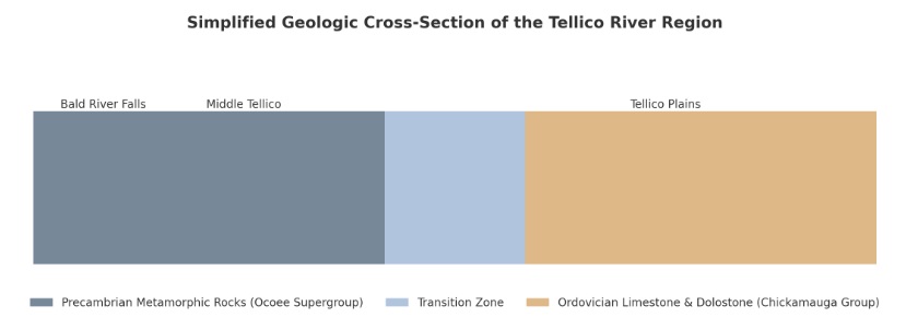
The falls themselves are more than a dramatic backdrop. They are part of a deeply eroded geologic puzzle. With my background in geology, I always try to research and understand the rivers I paddle. Quite candidly, I will tell you it is never easy to gain a full understanding of a river’s geologic history. As water rushes down a river bed such as the Tellico River, it cuts through many geologic strata. Not only does water erode and expose rock layers, it also moves rocks from different geologic time periods. Add uplift and depositional phases to the story, and you have a complex answer.
At the beginning of the run, Precambrian Metamorphic rock gives us technical rock gardens and class II/III rapids and dramatic drops. Forged under intense pressure and heat when this land was once buried deep in the crust, today, the Tellico River slices through this ancient formation, revealing layers of history in every bend.
Further down river, the water cuts through less-dramatic Middle Ordovician sedimentary limestone for a more gradual gradient and gentler paddling experience.
Are you confused, yet? Here’s a simplified geologic cross-section of the Tellico River region, showing how the bedrock changes from Precambrian metamorphic rocks near Bald River Falls and the Middle Tellico Put-In, to Ordovician sedimentary rocks downstream near Tellico Plains.
From the Falls to the Foam
As the scene shifts to a POV from my kayak, the adventure begins in earnest. The Middle Tellico section, downstream of the Bald River confluence, offers a classic Class II/III whitewater run with technical lines, boulder gardens, and plenty of playful waves. The water was at a friendly flow (about 1.8), enough to test my reflexes without overwhelming my capabilities.
Whitewater is a moving classroom. Each drop, each eddy, each rapid tells a geologic tale. Many of the boulders that define this stretch were fractured and shoved here by the wild forces of freeze-thaw cycles and flood events. These rocks, part of the Ocoee Supergroup, date back more than 700 million years and have been slowly sculpted by water into the playground we paddle today.
Reading the River From a Kayaker’s Perspective
Paddling with purpose means more than just chasing thrills. I like to imagine how this river once looked. Before roads, bridges, or cameras, how did the Tellico cut its path through these hills? What tectonic forces lifted these ridges skyward, and how much longer will the river take to grind them back down?
Geologic history is much more complicated than just a record of singular events. Instead of singular events, we must consider uplift due to tectonic collision, erosion and mass-wasting events due to rainfall and gravity, and depositional processes due to a river’s variable velocity of flow.
Those forces act over different time scales, sometimes concurrently and sometimes independently. All combined, those forces give us the river we have today. But of course, those forces are still acting upon the landscape and tomorrow’s river will be slightly different than today’s river.
Whitewater paddling brings us intimately close to the landscape. Looking closer, we don’t just see the water, we also sense the rocks beneath. Bouncing off, sliding through, and sometimes flipping over the rocks reveals more than just happenstance. Each rock’s placement has a cause and effect. If you paddle enough, you will begin to understand this relationship. Each kayaking “research” trip adds another layer to my own understanding of the land beneath my boat.
The Feel of the Tellico
What begins as a delicate paddle through a technical rock garden continues into (easy) Class III read-and-run rapids and culminates into a gentle paddle-out toward the take-out. The Tellico River remains one of my favorite runs, not just for its unreliable and variable whitewater but for its deep sense of place. Every time I paddle the Tellico, I see something new: a recently fallen tree lodged in a rock jam, a large rock in a slightly different position, a change in water color as sediment washes in from surrounding mountain streams, or a precarious strainer just waiting to entrap an unsuspecting kayaker.
Whether you’re a paddler with a thirst for wild places, a geologist trying to understand uplift and erosion, or just someone curious about the stories told by stone and water, I encourage you to experience the Tellico for yourself either from the safety of the newly constructed pedestrian bridge or from the exhilarating vantage point of an experienced and capable kayaker paddling through the treacherous rapids.
SYOT! (See You On The River!)
Clyde Outside
Leave a Reply
You must be logged in to post a comment.